Geopath Wiriehorn


- 3:30 h
- 9.19 km
- 622 m
- 621 m
- 1,410 m
- 2,032 m
- 622 m
- Start: Wiriehorn mountain station (Nüegg), Zwischenflüh
- Destination: Wiriehorn mountain station (Nüegg), Zwischenflüh
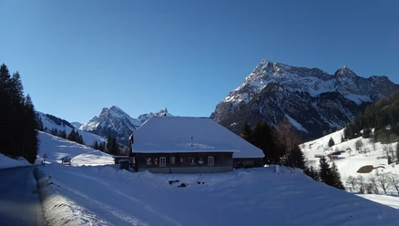
"Look from mountain and valley..." What evokes feelings of home in us Diemtigtalers has been shaped, moved, layered, and eroded again over millions of years. How does a sea become a cultural landscape with grazing cows? How does the Wiriehorn get its typical shape? Whose traces of earlier times are still recognizable in the terrain today?
The rock of the Wiriehorn is very old, formed around 240 million years ago. At that time, dinosaurs also lived on our planet. Around 240 million years ago, large areas were extensively covered by a sea. Dead plants, shells, and scales settled on the sea floor. They mixed with minerals, solidified, and turned to stone. Later – during the formation of the Alps – the rock was uplifted and moved here. Today it forms the summit of the Wiriehorn.
More exciting questions and answers await you on the Geopath around the Wiriehorn.

Good to know
Pavements
- Street (16%)Trail (19%)Path (65%)
Best to visit
- suitableDepends on weather
Directions
Follow the Geopath from the Wiriehorn mountain station (Nüegg) towards Underi Heitere. Over the Bodeflue to the Wirie, you will pass interesting viewing points and stations. From here, you have the possibility to climb the summit of the Wiriehorn. For this, you need an additional approx. 1 hour 30 minutes. Otherwise, the Geopath leads you around the Wiriehorn, further over Gurbs Metteberg, Abendmatte to Tubefärich. The last section of the path runs past the Bergrestaurant Schwarzenberg back to the mountain station. The path is marked with white direction indicators and a green route field.
Equipment
Sturdy footwear, weather-appropriate clothing, provisions and drinks for the way
Directions & Parking facilities
- Getting there
Motorway A6 Bern direction Zweisimmen, turn left 1 km after the Simmenfluhtunnel towards Diemtigtal. Follow the Diemtigtal road uphill for 13 km. 200 m before the Seebergsee (Zwischenflüh) junction, turn left over the bridge (signposts Enetchirel / Entschwil). Take the first turn right and follow the signs "Berghotel Wiriehorn" or "Bergrestaurant Schwarzenberg" for 5 km.
Alternative with chairlift
Motorway A6 Bern direction Zweisimmen, turn left 1 km after the Simmenfluhtunnel towards Diemtigtal. Follow the Diemtigtal road uphill for 11 km to the Wiriehorn valley station. From here, the chairlift of Wiriehornbahnen takes you up to the Nüegg mountain station (observe operating times: www.wiriehorn.ch).ParkingAt the Wiriehorn valley station you will find around 1000 parking spaces. The number of parking spaces at the mountain station is limited.
Public transportationBy train to Oey-Diemtigen station (Spiez–Zweisimmen line). Then by post bus to the "Riedli, Wiriehorn valley station" stop. From here, the chairlift of Wiriehornbahnen takes you up to the Nüegg mountain station (observe operating times: www.wiriehorn.ch).
Additional information
- A flyer with an overview map is available at the office of the Diemtigtal Nature Park.
Diemtigtal Nature Park
Bahnhofstrasse 20
3753 Oey
T 033 552 26 00
info@diemtigtal.ch
www.diemtigtal.ch
Open or closed?
Check our > summer sports report
Food options
Berghotel Wiriehorn: Restaurant at the mountain station of the Wiriehornbahnen (open when the lift is operating)
T 033 684 12 42, www.wiriehorn.ch
Bergrestaurant Alp Schwarzenberg: Restaurant reachable by a short walk from the Wiriehorn mountain station
T 033 684 13 97 or M 079 427 81 87, www.alp-schwarzenberg.ch
Did you enjoy this route?
We look forward to your review on > outdooractive License (master data)
Author´s Tip / Recommendation of the author
A detailed Geopath brochure with geological background information is available for CHF 3 at the office of the Diemtigtal Nature Park.
Nearby



Download GPX file