High-altitude hike on the Wasserngrat


- 4:00 h
- 10.90 km
- 411 m
- 414 m
- 1,939 m
- 2,202 m
- 263 m
- Start: Betelberg
- Destination: Wasserngrat
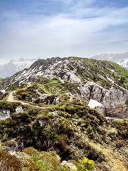
From the mountain station Leiterli, we follow the high-altitude trail towards Trütlisberg Pass. At the junction P.1983 we turn right and soon after ascend the summit of Stübleni on the left (it can also be crossed below). From the summit, there is a great view of the Gryden, a term probably derived from Chride (chalk). The sinkholes (also called dolines) formed through the slow dissolution of the white gypsum rock by rain and underground drainage.
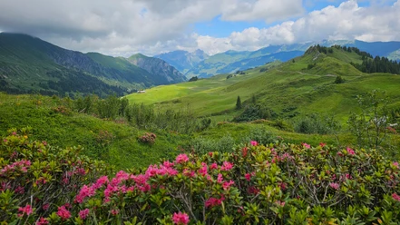
Impressively, we continue hiking right through the unusual rocky landscape, winding around numerous craters. At the small shelter, we leave the landscape and shortly afterwards reach the Trütlisberg Pass. We cross the small hill of the Tube a bit below and soon arrive at the next pass, Türli. To the right leads into the long Turbach valley dotted with many alpine huts. However, we remain on the path towards Wasserngrat, ascend a little more upwards on the ridge, then cross Louwenehore on the south side. Thus we reach the next pass height, Turnelssattel, from where you can look right into the Turneltal. First directly on the crest, then a bit below Brüeschegrat, it passes a shelter. Upon reaching the summit of Wandeliflue (P.2202), we move again briefly directly on the ridge, then continue just below Wasserngrat without major elevation differences. This crossing includes some slightly exposed sections that could become unpleasant when wet or icy. The final descent down to the mountain station of the Wasserngratbahn then proceeds without problems.

Good to know
Pavements
Best to visit
Directions
Equipment
Directions & Parking facilities
Arrival: by bus from Lenk train station to the valley station Betelberg, cable car to Betelberg, mountain station Leiterli
Return: by bus from Gstaad, Wasserngratbahn to Gstaad train station
Additional information
Literature
Hiking book Bernese Oberland of the Bernese Hiking Trails
License (master data)
Safety guidelines
Map
Swisstopo hiking map: 263T Wildstrubel 1:50,000
Nearby