Idyll high above the Gadmen valley

- 5:00 h
- 9.32 km
- 1,090 m
- 1,040 m
- 1,129 m
- 2,158 m
- 1,029 m
- Start: Gadmen, Fuhren
- Destination: Gadmen, Post
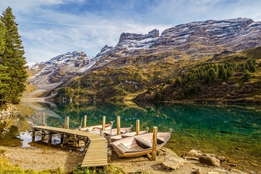
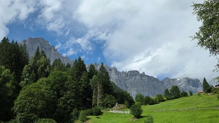
The easy warm-up from Fuhren lasts only briefly, and then the ascent begins across meadows, along a stream, and through the Schaftellouwi forest. The mountain path is partially quite steep and strenuous; however, the traffic noise from the Sustenpass road soon fades far behind. The view, in contrast, becomes increasingly better. Especially the limestone cliffs of the Gadmerflöö, also called the Gadmer Dolomites, rise spectacularly on the other side of the valley. Extending from them, the Titlis is also visible, unmistakable with its antenna slightly below the summit. After the flat Tagweid, there are a few steep steps and high foot placements on the upper path section, where even the hands are briefly used. However, these spots are not dangerous. Above that, the path between rock slabs and sparse grass can occasionally be a bit indistinct, and then suddenly the dark green jewel appears in a hollow between gneiss peaks and alpine pastures. No road, no mountain hut disturbs the silence. The picnic is taken from the backpack, and maybe some will even unpack swimming gear. In earlier winters, avalanches have often come down from the slopes above the Gadenlouwisee, rushing over the frozen lake like a ski jump and thundering down through the Farlouwi gorge into the valley. They repeatedly struck a hamlet, of which only a few walls remain today. The descent first follows the same path back to Tagweid, then descends through the Farlouwi forest toward Gadmen. It goes quite briskly downhill over numerous switchbacks. Those who love blueberries should plan enough time. Hopefully, there is still time in Gadmen for a cozy end to the route on a sunny restaurant terrace.
Text: Fredy Joss

Good to know
Pavements
Best to visit
Directions
Fuhren – Tagweid – Gadenlouwisee – Tagweid – Gadmen
Equipment
We recommend the following equipment: sturdy mountain boots, medium-sized backpack with hip belt, sun protection, rainwear, hiking poles, first aid kit, picnic, sufficient fluids, mobile phone.
Directions & Parking facilities
Arrival: by PostBus from Meiringen or Innertkirchen to Gadmen/Fuhren
Return: by PostBus from Gadmen/Post back to Meiringen or Innertkirchen
Additional information
Berner Wanderwege, 031 340 01 01, info@beww.ch, bernerwanderwege.ch
License (master data)
Author´s Tip / Recommendation of the author
Those who want to discover the region from a culinary perspective should try a Hasli cake once. With this treat, the calories burnt before are almost replenished.
Safety guidelines
This route runs entirely or partly on marked paths of the category mountain hiking trail.
Map
swisstopo hiking map: 255T Sustenpass, 1 : 50,000
Nearby