In the recreational area of Unterseen and Interlaken


- 2:10 h
- 8.97 km
- 57 m
- 55 m
- 558 m
- 614 m
- 56 m
- Start: Interlaken West
- Destination: Interlaken West
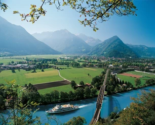
At Interlaken West station, follow the sign for Neuhaus. First, after arriving by bus or train, you have to pass under the tracks. After climbing the stairs of the underpass, continue with a sharp turn and turn onto the canal promenade around the reception building of the Lake Thun shipping. What appears as a side arm of Lake Thun is the artificially created shipping canal, which you then follow. Shortly before the mouth into Lake Thun, you cross the Aare.
On the right you can see the ruins of Weissenau. The castle was built in the 13th century to control goods traffic. It was abandoned in the 16th century and then fell into ruin. Shortly afterwards, at a parking lot in Weissenau, the path turns left and leads into the Weissenau nature reserve. Several spots allow nature enthusiasts to observe birdlife. The path runs close to the shore, with an unobstructed view of Lake Thun and the surrounding mountains. Soon the beach at Neuhaus is reached. Over the parking lot and through an underpass, you reach the Lombach bridge and the Lombach promenade. The sign here indicates Unterseen. The sound of the stream accompanies hikers for the next two kilometers to St. Niklausen. At the bus stop with the same name, continue on foot at the foot of the Harder towards Interlaken East. Only after passing the cemetery does the path turn towards Interlaken West and skirts Untersee. This once strategically important place burned down twice in its history and was granted city rights as early as the 12th century. In short, the destination is reached at Interlaken West station.

Good to know
Pavements
Best to visit
Directions
Interlaken West - Weissenau – Neuhaus - St. Niklausen - Unterseen - Interlaken West
Equipment
We recommend the following equipment: lightweight trekking shoes, light backpack, sun protection, rain jacket, small first aid kit, light picnic, sufficient fluids, mobile phone.
Directions & Parking facilities
Additional information
Berner Wanderwege Association, Bern, Tel.: 031 340 01 01, Email: info@beww.ch, Homepage: www.bernerwanderwege.ch
Literature
Hiking book Short hikes 2 of the Berner Wanderwege
License (master data)
Safety guidelines
This route runs exclusively on marked paths of the hiking trail category.
Map
Swisstopo hiking map 254T Interlaken 1:50,000
Nearby


")
Download GPX file