Lohner Western Flank Trail - Adelboden


- 8:30 h
- 13.25 km
- 1,200 m
- 750 m
- 1,232 m
- 2,368 m
- 1,136 m
- Start: Adelboden Oey
- Destination: Engstligenalp
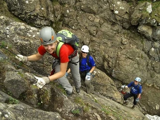
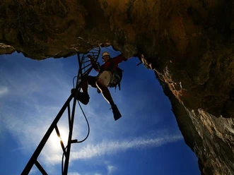
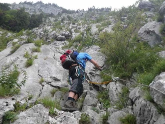
The route of the ascent path from Adelboden-Oey (1238 m) to Bunderalp is defined by the (toll) road. Up to the Bunderle parking lot (1360 m), you follow the asphalt strip, in the further course you can shorten its wide loops on the white-red-white hiking trail. Eventually, you reach the extensive alpine pastures with two summer restaurants; at the last alpine hut, I de Schrickmatte (1812 m), the route splits, blue markers replace the red ones, which means – alpine routes. They certainly deserve this classification; a former municipal clerk of Adelboden is said to have been quite shocked when looking over the cliff above Schrickmatte. Since then, the key point of the upper path is called "Schryberschreck". The approximately 60-meter-high steep step, upon closer inspection, turns out to be quite harmless; chains secure the zigzag path through the steep gully. The lower hut approach initially crosses flat towards the rock base, then runs over narrow ledges before ascending to a narrow steep gully behind a detached tower in easy rocky terrain. This can be easily climbed via a longer wooden ladder and leads to a narrow squeeze. Immediately following are two iron ladders, then a deep, rocky gully with some height loss must be crossed. Via more iron rungs you reach easy terrain, and the mini-ferrata becomes a hiking trail again. It first crosses, still ascending, to a rocky gully. You pass it and ascend steeply along its right edge (a chain) to a rock barrier (around 2090 m). At its foot, the upper approach (signpost) joins from the left. The well-stepped, about twenty-meter-high rise ("Zürchertritt") is softened by thick chains, as is a small rock step a little higher. Afterwards, you cross two cirques, descending about thirty meters, to the Lohner hut (2171 m), at the sight of which the expression "eagle's nest" involuntarily comes to mind. The view wanders upward (to impassable rock walls), downward (over dizzying cliffs), and across (to the onward path). What a backdrop! The onward path initially follows over the Witi Chume to the Engstligenalp, down to the bottom of the powerful debris cirque of the Witi Chume, before zigzagging along the edge of a green ridge towards the rock base of the Mittaghorn (2678 m). The subsequent crossing out to a lookout point (2367 m, memorial plaque), which mediates the transition from the northern to the western flank, runs over steep slate slopes and is additionally threatened by falling rocks: So be cautious! At the highest point of the tour, you then have the opportunity to enjoy the view over the Engstligental and the two main peaks above Adelboden, Gsür and Albristhorn; to the south stands the massive Wildstrubel with its white cap. The onward path runs between rock (above) and rock (below), about one kilometer high above the valley floor, crosses another debris basin descending to the next notable ridge, P. 2259 m. Losing more height, you reach the amphitheater of Luserbleika, overshadowed by rock walls. The sometimes rather sparse trail aims for the rock base, finally passing "Johann’s Luser Bar" with a bench and leading out to the flower meadows above the green summit of Lusers (approx. 2230 m), where the difficulties end. There is still a bench here, and many will gladly sit down to review their experiences and/or calm their overstrained nerves. However, high-proof drinks are only available (if needed) over on the Engstligenalp (1965 m), which is reached on a well-marked path descending first, then ascending again. Those who wish can also descend directly to the valley station of the cable car. The decent route (turnoff at P. 1956 m; signs) avoids the wild gorge of the Ärtelenbach on the north side and leads down in many bends to Unter dem Birg (1400 m).

Good to know
Best to visit
Equipment
We recommend the following equipment: Official via ferrata gear, gloves, sturdy mountain boots, medium-sized backpack with hip belt, sun protection, rainwear, first aid kit, picnic, sufficient fluids, mobile phone.
Directions & Parking facilities
License (master data)
Safety guidelines
According to the via ferrata scale: B (K2, moderately difficult)
Nearby