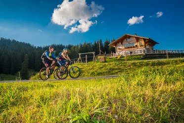
Panorama bike route - Habkern to Thun


- 3:40 h
- 41.41 km
- 874 m
- 1,373 m
- 556 m
- 1,409 m
- 853 m
- Start: Habkern
- Destination: Thun
The spectacular route starts in Habkern with a climb to Waldeggallmi. The incline is technically easy to ride. However, you should still expect some sweat and effort. Once at the top, the route mostly leads downhill, but with constant ups and downs. The entire route runs above the deep blue Lake Thun mainly on paved side roads towards the west. Well-kept houses, snow-covered mountains, and the lake landscape form a classic postcard idyll. The view from Beatenberg to the impressive triad of Eiger, Mönch, and Jungfrau is breathtaking. After passing through Beatenberg, Europe's longest village, you first go downhill to Wiler and then via Schwanden and Teuffenthal over Steffisburg to Thun. On this dreamlike route, you can easily escape everyday life. The impressions gathered will still be unforgettable at the end of the route in Thun, the charming small town.

Good to know
Pavements
Best to visit
Directions
Additional information
The information regarding duration, fitness, and technique depends on the chosen type of bike (mountain bike, e-bike, e-mountain bike, touring bike, road bike). These are average reference values.
Interlaken Tourism
Marktgasse 1
CH-3800 Interlaken
T +41 (0)33 826 53 00
mail@interlakentourism.ch
www.interlaken.ch
License (master data)

Safety guidelines
Nearby