Seebergsee - To the wonderful Seebergsee (Day 1)


- 6:10 h
- 15.42 km
- 1,400 m
- 450 m
- 782 m
- 2,069 m
- 1,287 m
- Start: Oberwil i.S.
- Destination: Stierenberg (Stierenseeberg)
From Oberwil station into the village center, under the railway line and along the Hüpach to the valley road and the covered Simme bridge downwards. The ascent is quite steep, now going uphill on shortcuts over hay meadows and pastures, crossing the Rossberg road several times. You already enjoy a lovely view over the Simme valley to the main settlements of the Oberwil municipality: Waldried, Hüpach and Buusche. Following the road for longer sections you soon reach the mountain inn in a beautiful location on the Rossberg (after Weissenburg 50 min).
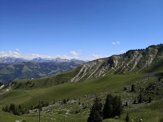
For another kilometer, the alp road must also be used. At the height (over Urscher to Seebergsee 3h15), where the road makes a wide left bend, turn right on a forest road to the farm. Ascending directly over the Egg, you soon reach the buildings at Horenegg. Now the forest road runs southwest through the swampy slope of the Niderhorn spur towards Dachweggraben, turns south before reaching the forest edge and follows the edge of the ditch to the Vordere Niderhornalp. The view to the peaks and pinnacles of the pre-alpine arc from Stockhorn to Gastloses is magnificent. Now follow an alp road ascending over the Egg and zigzag towards the green ridge of the Niderhorn by the huts at Hindere Niderhore. The Niderhorn is an extremely versatile summit. Not only hikers but also bikers choose it as a destination. Climbers gather on its east-facing vertical walls. But the unique panoramic view is especially delightful. Cross the ridge southwards, descend past impressive karst fields to the Luegle hut and, crossing an alp saddle near point 1851, reach the Seebergsee lined with spruces and Swiss stone pines. It is now just a stone's throw to Alp Stierenberg (Stierenseeberg).

Good to know
Pavements
Best to visit
Directions
Equipment
Directions & Parking facilities
Additional information
Literature
License (master data)
Author´s Tip / Recommendation of the author
Safety guidelines
Map
Nearby