To the Hinterburgseeli, the natural wonder on the Axalp


- 3:45 h
- 10.69 km
- 624 m
- 624 m
- 1,521 m
- 1,878 m
- 357 m
- Start: Axalp
- Destination: Axalp
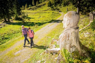
From the bus terminus at the Axalp, the route initially passes the alpine guesthouse eastwards on a well-developed hiking path. The incline remains moderate. Looking backwards, Augstmatthorn, Harder, and the Niederhorn rising behind can be seen. The rows of trees have noticeably thinned after severe storms and avalanches. From the tree stumps, students of the cantonal woodcarving school in Brienz have created diverse and original sculptures. Shortly after the junction in Färnigen, you cross the mountain ridge descending from the Axalphorn. The Hinterburgseeli, lying in a hollow, only comes into sight when you are almost right on its shore. Like a jewel, the blue-green water surface shines from the surrounding fir circle. The rock bands of the Oltschiburg tower mightily above. From the small lake, the path gently rises again to the pass at Alp Hinterburg. On the descent to the huts Uf der Flue, the deep view into the lower Hasli valley, which is crisscrossed by the silver ribbon of the Aare, captivates. The subsequent ascent is very steep on a narrow path through the flank of the Oltschiburg. Then it goes with slight ups and downs to the huts in Urserli (via Tschingel–Chüemad–Axalp 2h45; suitable only for sure-footed, fearless mountain hikers!). Along the way, splendid views over Lake Brienz. Caution is advised on the path to Chruttmettli, which leads along increasingly narrow, steep rock walls, from where a wide forest path leads down to Färnigen and back to the starting point at the Axalp.

Good to know
Pavements
Best to visit
Directions
Equipment
Directions & Parking facilities
Additional information
Hinterburgseeli Nature Reserve
- The area around the Hinterburgsee and the lake itself is located in a nature reserve, the marked rules must be observed.
- Land, soil, and waters are in private ownership of the Hinterburg alpine cooperative.
Bernese Hiking Trails Association, Bern, Tel.: 031 340 01 01, E-Mail: info@beww.ch, Homepage: www.bernerwanderwege.ch
Literature
Hiking suggestion from the Bernese Oberland hiking book, hiking book series of the BWW
License (master data)
Safety guidelines
This route runs wholly or partly on marked paths of the mountain hiking trail category
Map
Swisstopo hiking map 1:50,000 254T Interlaken
Nearby

Download GPX file