Towards the Wildstrubel massif


- 4:20 h
- 14.07 km
- 160 m
- 1,250 m
- 1,028 m
- 2,078 m
- 1,050 m
- Start: Rinderberg
- Destination: Lenk
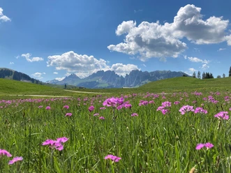
From the Rinderberg mountain station, we ascend directly on the ridge for 15 minutes and thus have already reached the highest point of the Rinderberg and also of the hike, the 2078 m high Hindere Spitz. Now follows a highly scenic hike, mostly on the ridge of the Gandlouenegrat to the south, with wonderful views over the green Saanenland and the Simmental with the glacier-covered mountains of Wildstrubel, Wildhorn, and Les Diablerets towering above. At the trail junction P.1939, we can descend directly to the Parwengesattel on the left or make a small detour via the Alp Parwenge on the right (about 15 minutes extra). If you choose the latter, you can stop at the alp (the ice cream is a highlight) or buy delicious alpine products. From Parwengesattel, it goes shortly on an alpine road to Undere Zwitzeregg and on a hiking trail to the Rüwlispass. The pass is formed by a small high plateau and is characterized by a small raised bog. On the alpine road, it goes gently downhill from the Rüwlispass to Alp Rüwlis. Here we keep right and follow a hiking trail through lonely forest areas and hidden alpine meadows into the Chatzestalde area. The view to Lenk and the nearby Albristhorn is overwhelming. From Chatzestalde, the path descends through wonderful forest down to Stutz and then further to the valley floor near Schadauli. The last section to the Lenk station follows the valley hiking trail.

Good to know
Pavements
Best to visit
Directions
Rinderberg - Gandlouenegrat - Parwengesattel - Zwitzeregg - Rüwlispass - Alp Rüwlis - Chatzestalde - Stutz - Bode - Lenk
Equipment
We recommend the following equipment: sturdy hiking boots, medium-sized backpack with hip belt, sun protection, rainwear, hiking poles, first aid kit, picnic, sufficient fluids, mobile phone.
Directions & Parking facilities
Arrival: by train to Zweisimmen, on foot (5 min) to the valley station of the Rinderberg cable car
Return: by train from Lenk to Zweisimmen
Additional information
Berner Wanderwege Association, Bern, Tel.: 031 340 01 01, E-Mail: info@beww.ch, Homepage: www.bernerwanderwege.ch
Literature
Hiking book Berner Oberland of the Berner Wanderwege.
License (master data)
Safety guidelines
This route runs wholly or partly on mountain hiking trails.
Map
Swisstopo hiking map: 263T Wildstrubel 1:50,000
Nearby

