Waldegg Trail - Beatenberg (signposted)


- 1:30 h
- 2.92 km
- 120 m
- 120 m
- 1,233 m
- 1,341 m
- 108 m
- Start: Waldegg Hohwald
- Destination: Waldegg Hohwald
The snowshoe route in Beatenberg/Waldegg starts a little above the Waldegg district in the Hohwald area. The starting point is reachable from the Waldegg bus stop in about 15 minutes.
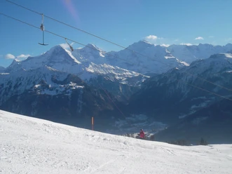
From Hohwald, the route first ascends northwards through the snow-covered Wychelmooswald towards Rischeren. At Rischeren, the Sundgraben is crossed. Then the trail continues steadily along the south slope towards Bödeli. On this part of the route, you enjoy a beautiful view of the Bernese Alps. At Bödeli, the route turns and leads down to the Sundgraben. After crossing it again, the path gently ascends through light forest and over open areas back to the starting point Hohwald.
The Waldegg Trail is ideal for beginners or as a finale for a half day of winter sports!

Good to know
Pavements
Best to visit
Directions
Waldegg Hohwald - Rischeren - Waldegg Hohwald
Equipment
We recommend the following equipment: sturdy and waterproof mountain boots, light to medium backpack, cold protection, sun protection, hiking poles, pocket first aid kit, snacks, tea in a thermos bottle, mobile phone.
Directions & Parking facilities
Additional information
Association Bernese Hiking Trails, Bern, Tel.: 031 340 01 01, E-Mail: info@beww.ch, Homepage: www.bernerwanderwege.ch
License (master data)
Safety guidelines
This route is signposted as a snowshoe route but not specially prepared.
Map
Swisstopo map 1208 Beatenberg 1:25'000
Nearby


")
")
Download GPX file