Bödeli Route


- 1:30 h
- 22.71 km
- 143 m
- 140 m
- 558 m
- 612 m
- 54 m
- Start: Interlaken, Interlaken Ost station
- Destination: Interlaken, Interlaken Ost station
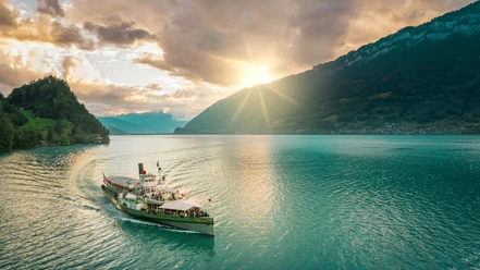
The route starts at Interlaken Ost train station and first follows the Aare River along to Lake Brienz. In Bönigen on the quay, you enjoy a great panoramic view over the turquoise water all the way to Brienz. The route continues over the Hauetenbach, followed by a short climb rewarded with a magnificent view over the so-called "Bödeli", the alluvial plain between Lake Thun and Lake Brienz. Ride along the Lütschine to the Gsteig church, where you cross a medieval bridge. Then continue through Wilderswil, past the well-known Unspunnen ruin, over the Rugen to Interlaken. There, the route runs along the shipping canal towards Lake Thun. A stop at the Weissenau nature reserve is worthwhile to visit the namesake ruin and enjoy the tranquility of nature. Via Neuhaus, along the Lombach, and through the charming old town of Unterseen, the route leads back to Interlaken.

Good to know
Pavements
Best to visit
Directions
Interlaken Ost – Wilderswil – Unterseen – Interlaken Ost
Behind the station, the path first follows the Aare and then Lake Brienz. A special treat is the panoramic view from Bönigen over the turquoise water to Brienz. After a short climb over the Hauetenbach to the "Chumm," the view stretches over the alluvial land built up between Lake Brienz and Lake Thun over millennia, including the world-famous tourist destination and the villages of Matten, Unterseen, Wilderswil, Ringgenberg, and Bönigen – this "Bödeli" rightly gives this route its name. Between the Lütschine, popular with river rafters, and the former military airfield Interlaken, where large events like the Trucker & Country or the Greenfield Festival take place annually, the route continues southwards to Wilderswil. The Gsteig church from the 12th century was formerly the main church for 9 communities between the Lauterbrunnen valley and the Bödeli. After crossing the medieval bridge from 1738, which has been equipped with a lifting device since the flood in 2005, the old village part Allmend of Wilderswil is reached. The path continues through Kirchgasse into Oberdorf. The route then passes the Unspunnen ruin through the Wagnerenschlucht gorge between the Small and Large Rugen to Interlaken. There, the path branches off and runs along the shipping canal towards Lake Thun. The Weissenau ruin was formerly where trade via ships on the Aare was controlled. The nature reserve of the same name offers many water birds a home. Via Neuhaus and through Eywald on the Lombach, the tourist center draws nearer again. The ride goes through the charming old town of Unterseen, the uppermost town on the Aare, continues over the Aare bridge to the Höheweg, Interlaken’s promenade, with an unobstructed view of the Jungfrau massif. Finally, the destination is reached at Interlaken Ost station.
Source: http://www.schweizmobil.ch/de/veloland/routen/route-0380.html
Additional information
The information on duration, fitness, and technique depends on the chosen bike type (mountain bike, e-bike, e-mountain bike, touring bike, racing bike). These are average guidelines.
Interlaken Tourism
Marktgasse 1
3800 Interlaken
Tel: +41 33 826 53 00
mail@interlakentourism.ch
www.interlaken.ch
License (master data)

Nearby


")

Download GPX file