Cholerenschlucht – the gorge of rushing waters


- 2:00 h
- 5.27 km
- 400 m
- 190 m
- 560 m
- 903 m
- 343 m
- Start: Hünibach, Chartreuse
- Destination: Thun, Wartboden
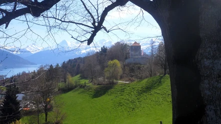
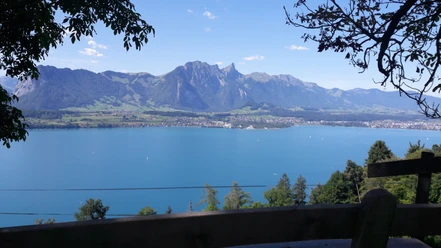
From the STI stop «Hünibach, Chartreuse» on line 21, the route leads up on Chartreusestrasse to Hünibachstrasse and further to Kohlerenweg. This section on a hard surface takes just under fifteen minutes. Then it goes over a field path into the forest and into the Cholerenschlucht. Along the rushing water and past rugged conglomerate rocks, the route leads over wooden boardwalks and stairs through the forest. Especially after rainfall, the smaller and larger waterfalls are very impressive. After a short ascent, there is a large moss-covered boulder on a plateau. There, a wooden table and benches invite you to rest. The large boulder is also ideally suited as a lookout over the enchanted water world in the shade of the forest. From the picnic area, the path finally continues in a zigzag upwards to Scheidweg. Arriving there, the hard surface road leads left to Goldiwilstrasse. Opposite the STI stop «Scheidweg», the hiking trail continues towards Rabenflue. Around 30 minutes should be allowed for the forest path. At 864 meters above sea level, you enjoy a wonderful view of the mountains and the lake. The return goes in a zigzag down to the STI stop «Wartboden» of lines 31/32. Alternative routes lead over Brändlisberg to the STI stop Steffisburg «Glockenthalerhof» on line 1 or via Göttibach down to the STI stop «Thunerhof» on line 21. Transport Company STI

Good to know
Pavements
Best to visit
Directions
Hünibach - Cholereschlucht - Rabenflue - Wartboden
Equipment
We recommend the following equipment: light trekking shoes, light backpack, sun protection, rain jacket, pocket first aid kit, light picnic, sufficient fluids, mobile phone.
Directions & Parking facilities
Getting there: By STI bus no. 21 or 25 from Thun train station to Hünibach, Chartreuse
Return: By STI bus no. 31 or 32 from Wartboden
Additional information
Berner Wanderwege, Moserstrasse 27, 3000 Bern 22, info@beww.ch, 031 340 01 01
License (master data)
Author´s Tip / Recommendation of the author
Safety guidelines
This hike runs exclusively on marked paths of the hiking trail category.
Map
Swisstopo hiking map 1:50,000 253T Gantrisch
Nearby


