From Bidmi over the wild side to Planplatten


- 5:15 h
- 14.62 km
- 949 m
- 949 m
- 1,320 m
- 2,243 m
- 923 m
- Start: Bidmi intermediate station
- Destination: Bidmi intermediate station
The hike starts and ends at the intermediate station Bidmi of the Hasliberg-Reuti - Mägisalp gondola. It leads over several alpine pastures off the beaten paths to Planplatten.
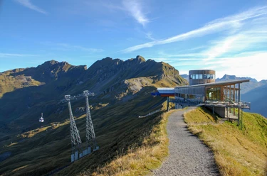
From the intermediate station Bidmi head southeastwards down the street, then over Alp Gwiggi to Winterlücke. From there on the asphalt road up to Moosbielen, further to Schlafbielen. Up to Alp Schlafbielen you are hiking on alpine roads, from there the path narrows to the mountain hiking trail, which we follow for the last 300 meters of altitude. The view is impressive and becomes increasingly impressive. On Planplatten we can stop at the Alpentower and take the gondola down. For those who want it even sportier, go southwards down to Gummenalp, always with the Engel- and Wetterhörner in view. At Gummenalp we meet the Muggenstutzweg, popular with families, and soon reach the intermediate station Bidmi again.

Good to know
Best to visit
Directions
From Bidmi go southeastwards down the street, then over Alp Gwiggi to Winterlücke. From there on the asphalt road up to Moosbielen, further to Schlafbielen. From here follow the mountain hiking trail up to Planplatten. Past the Alpentower and descent to Gummenalp, there follow the Muggenstutzweg and take the path back to Bidmi.
Equipment
Normal hiking equipment, sturdy hiking shoes.
Directions & Parking facilities
From Brünig Pass to Hasliberg-Reuti.
Paid parking lot at the cable car station.
From Interlaken or Lucerne to the Brünig Pass height, from there by post bus to Hasliberg-Reuti. Further up by gondola to Bidmi.
Additional information
Haslital Tourism, Tourist Center Meiringen, 3860 Meiringen, Tel. +41 (0) 33 972 50 50, www.haslital.swiss
Literature
Jochen Ihle / Toni Kaiser: The 55 most beautiful hikes in the Bernese Oberland. ISBN 978-3-03865-073-7, Rothus Medien, Solothurn, www.wandershop-schweiz.ch
License (master data)
Author´s Tip / Recommendation of the author
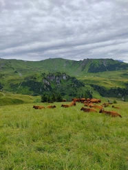
Keep your eyes open while hiking, you might spot chamois on the southern slopes of Planplatten. Possibly bring binoculars.
Safety guidelines
Hike on marked mountain trails. Difficulty: T2.
Map
Map 1:50 000, 255T Sustenpass.
Nearby

Download GPX file