Horizontweg – border and ridge hike in the heart of Switzerland


- 3:15 h
- 10.21 km
- 201 m
- 780 m
- 1,819 m
- 2,241 m
- 422 m
- Start: Planplatten (Alpentower), aerial cableway
- Destination: Engstlenalp
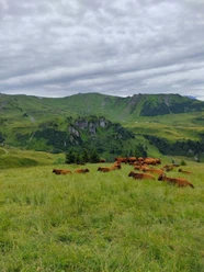
The location in the heart of Switzerland is accurate, as Aelggi, the center point of Switzerland, is only a few kilometers away. The route is designated from the starting point as Via Alpina 1 by Wanderland Switzerland. Also, all signposts show the destination Engstlenalp. At the mountain station Planplatten, now named Alpentower, it is worth visiting the terrace to enjoy the view to the west. From here, you can make out Lake Brienz, the Aare valley plain, or the Wetterhorn. The first intermediate goal, Balmeregghorn, is reached alternately downhill and uphill on a mountain path. To the right, the view falls into the Gental and the Gadmerflue. Balmeregghorn is the highest point of the hike. The following ridge trail forms the canton border to Obwalden until after the Erzegg ski lift. On the left, you can see Lake Melch and later Lake Tannensee. On the ridge, later over alpine pastures, you descend to Lake Tannensee. With a bit of luck, you can spot marmots. After the alpine settlement Tannalp, there is a passage with exposed sections at Spycherfluh. These are equipped with a rope; surefootedness is necessary. The change from Obwalden to Bern canton area happens unnoticed. Over an alpine pasture and streams, you reach the end of the hike at the Engstlenalp bus stop (engstlenalp-bus). Finally, you should not miss the idyllic Engstlensee. Cool, clear water is relaxing and rewards you for the physical effort.

Good to know
Pavements
Best to visit
Directions
Equipment
Directions & Parking facilities
Outbound: By train via Interlaken Ost to Meiringen, then by aerial cableway over Hasliberg Reuti and Mägisalp to Alpentower (Planplatten)
Return: By Engstlenalp Bus from Engstlenalp to Meiringen, then by train.
Additional information
Literature
Hiking book Panoramic hikes of the Bernese Hiking Trails
License (master data)
Safety guidelines
This route runs wholly or partly on marked paths of the mountain hiking trail category.
Map
Swisstopo hiking map 1:50,000 255T Sustenpass
Nearby

