From Stockhorn to Chrindi middle station


- 2:30 h
- 6.20 km
- 170 m
- 672 m
- 1,596 m
- 2,190 m
- 594 m
- Start: Stockhorn, mountain station.
- Destination: Stockhorn, Chrindi middle station.
The Stockhorn is one of the most popular panoramic mountains in the Bernese Oberland. From Erlenbach im Simmental, the Stockhorn cable car takes you up to the summit. At the top, you are welcomed by the modern panoramic restaurant and there is much to offer. Through a rock tunnel, you reach the well-secured panorama viewing platform in the northern face of Stockhorn. With a bit of thrill, you enjoy a great view of the town of Thun and Lake Thun as well as the Swiss Plateau extending far into the Jura.
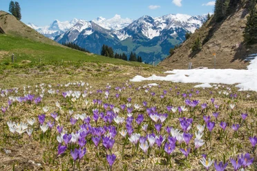
The panoramic view continues at the actual summit, which you can reach in a few minutes from the mountain station. The short summit path is also an alpine flower trail. Depending on the season, different flowers and shrubs bloom, with their names displayed on small signs. But even on the downhill hike to the Chrindi middle station, a rich flora can be admired along the trail. There is an opportunity to stop at the mountain guesthouse Oberstockenalp and around the Ober- and Hinterstockensee, there are beautiful resting places by the water.

Good to know
Pavements
Best to visit
Directions
Equipment
Directions & Parking facilities
Additional information
Stockhorn cable car, Tel. +41 (0) 033 681 21 81, www.stockhorn.ch
Lenk-Simmental Tourism, Tel. +41 (0) 033 736 35 35, www.lenk-simmental.ch
Literature
Jochen Ihle / Toni Kaiser: The 55 most beautiful hikes in the Bernese Oberland. ISBN 978-3-03865-073-7, Rothus Medien, Solothurn, www.wandershop-schweiz.ch
Jochen Ihle / Toni Kaiser: The 101 most beautiful hikes in Switzerland. ISBN 978-3-03865-041-6, Rothus Medien, Solothurn, www.wandershop-schweiz.ch
License (master data)
Author´s Tip / Recommendation of the author
Safety guidelines
Map
Map scale 1:50 000, 253T Gantrisch.
Nearby


")
")
")