Grenchegalm – from the spa landscape into the land of the spotted cattle

- 4:30 h
- 12.09 km
- 572 m
- 1,400 m
- 841 m
- 1,879 m
- 1,038 m
- Start: Schwefelbergbad
- Destination: Oberwil i.S.
The historic facade of the Romantik spa hotel Schwefelbergbad gives the modern spa operation a nostalgic touch. The sulfur spring was already documented in 1561. However, permission for a bathing facility was only granted in 1822. As the last witnesses of the once proud spa tradition in the canton of Bern, the Schwefelbergbad and the spa center at Lenk represent an endangered tourism sector. Behind the hotel, the mountain path rises steeply towards the Egg, which descends from Ochsen. Through loose mountain forest and crossing a scree field, one reaches the dilapidated Ritz hut. The narrow path now leads high above the Hengstschlund almost level into the valley towards the huts of Oberalpigle. Some exposed spots require special caution (monitor children!). The walls of Ochsen and Alpiglemären tower mightily over the mountain basin.
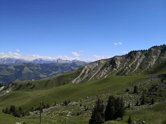
In slight ups and downs, the path crosses the steep flank beneath the rugged cliffs to the impressive Frilismad hut. Along a pasture fence, it goes very steeply up a mountain ridge, then continues on a magnificent high-altitude hike to the pass summit. Along the way, there are incomparable views into the valley basin of Hengstschlund, bounded by Widdersgrind, Schibe, and Märe. The view from Grenchegalm is magnificent: through the green high valley of the Morgete stream with the hut groups of Morgete, you can see the Gantrisch.
In a saddle gap, the sharp tooth of the Stockhorn is visible. Also, Wetterhorn, Schreckhorn, and Eiger are framed by wild peaks. Looking westward, the view extends over Schwyberg and La Berra to the distant Jura.
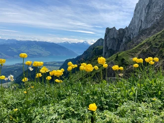
Very close lies the Schattigseeli, nestled on a moraine hill. Here, one heads south towards Lohegg, a saddle on the ridge of the nearby Widdersgrind. The Bernese high Alps now appear free and unobstructed.
The descent over the Alp Nüeberg to Domeren and on the winding alpine road to Nässli is like a panorama trail. Through the Niedersimmental, you can see the Thunersee, the Faulhorn area, and the Wetterhorn, with the peaks of the Alpine crown limiting the horizon. Off the road, the path goes down through the steep forest slope on narrow mountain paths. At Nidermatti, the road is crossed twice, after which the trail turns towards the Hüpbach and descends equally steeply along it to Oberwil. The beautiful church, together with the parsonage and the surrounding historic residential houses, forms a picturesque hamlet worth seeing. The village and railway station lie a little lower and are reachable within a few minutes.

Good to know
Pavements
Best to visit
Directions
Equipment
Additional information
Literature
License (master data)
Safety guidelines
Map
Nearby