The classic among the Pre-Alpine high-altitude hikes


- 4:20 h
- 11.25 km
- 1,000 m
- 301 m
- 1,579 m
- 2,140 m
- 561 m
- Start: Wasserscheide
- Destination: Stockhorn
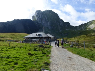
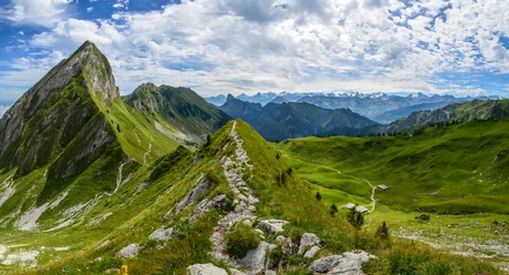
The path was created in the early 1970s and quickly became a classic among high-altitude hikes in Switzerland. What is well known and praised is correspondingly well frequented. As tempting as the descriptions of these hikes on the internet may sound, the view from Stockhorn must be earned with sweat. Starting from the hiking starting point at the Wasserscheide bus stop, the destination Stockhorn is specified. Following an alpine road, one ascends to the alpine farm Obernüne. This is the last opportunity to stop for refreshment before the Stockhorn summit restaurant. The ascent continues on a mountain path to Leiterepass. The deserved break is enriched by the view: the gaze sweeps north across the nearby elevations of Selibühl and Gurnigel, over the Central Plateau to the Jura. The towers on Chasseral, Ulmizberg, or Bantiger facilitate orientation. After a short descent, the high-altitude hike continues. To Oberi Walalp, one walks without major altitude differences. Stockhorn, Niesen, Eiger, Mönch, and Jungfrau can be seen along stretches. The last section is tough. However, the view at the destination can make up for much effort: the Central Plateau and the Jura, the city of Thun, and Lake Thun lie at the viewer's feet. The gaze falls on countless mountain peaks. Those who prefer it leisurely can enjoy the view from the newly constructed platform. As a bonus, the summit offers a 360-degree view. A panorama board names the mountains. Filled with beautiful impressions, one can start the return journey.

Good to know
Pavements
Best to visit
Directions
Wasserscheide - Leiterepass - Oberi Walalp - Baachegg – Stockhorn
Equipment
We recommend the following equipment: sturdy and waterproof mountain boots, a light to medium backpack, protection against cold, sun protection, hiking poles, first aid kit, snacks, tea in a thermos bottle, mobile phone.
Directions & Parking facilities
Arrival:
By BLS to Thurnen (or Schwarzenburg) and then by bus to Gurnigel, Wasserscheide
Return journey:
By cable car to Erlenbach im Simmental, then continue with BLS from Erlenbach station
Buy discounted hiking ticket online:
Additional information
Bernese Hiking Trails Association, Bern, Tel.: 031 340 01 01, Email: info@beww.ch, Homepage: www.bernerwanderwege.ch
Literature
Hiking book panoramic hikes of the Bernese Hiking Trails
License (master data)
Author´s Tip / Recommendation of the author
A discounted hiking ticket is available for this hike: Hiking ticket Gurnigel - Stockhorn
Safety guidelines
This route runs entirely or partially on marked paths of the category mountain hiking trail
Map
Swisstopo hiking map 1:50,000 253T Gantrisch
Nearby
")
")
")