To the most famous summit of the Bernese Pre-Alps


- 3:40 h
- 9.69 km
- 700 m
- 780 m
- 1,512 m
- 2,173 m
- 661 m
- Start: Wasserscheidi
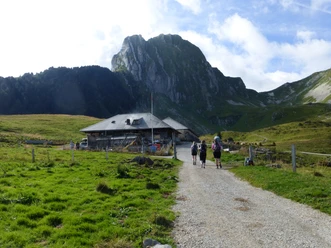
- Destination: Underi Gantrischhütte
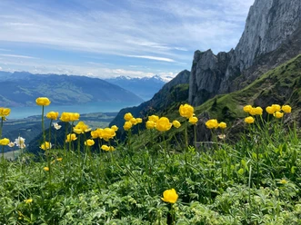
From Gurnigel, Wasserscheidi, take a wide path following the signs towards Leiterepass. After the Gantrischbeizli at Alp Obernünene, the path ascends moderately to the pass height between Gantrisch and the steep tooth of the Nünenenflue, from where a magnificent panorama of the Bernese Alps is presented for the first time. After a short descent from the pass, take the path towards Schibespitz and Morgetepass. Ascending gently, you cross the southern flank of the Gantrisch. Just below the Schibespitz, the southwest ridge is reached. Follow this now northwards to the summit of Gantrisch. Shortly before the summit, the partly exposed final ascent begins, equipped with wire ropes. After exiting this section, it is only a few meters to the left to the breathtaking summit lookout.
Return via the same path, following the beautiful southwest ridge towards Schibespitz. Crossing the scenic Schibespitz, continue along the ridge until the Morgetepass. In the summer months, a small "kiosk" at the pass surprises visitors with offerings of cold drinks and alpine cheese. Following the signs towards Underi Gantrischhütte, descend northwards, first through a steep mountain slope and then soon on a wide path. Shortly after the small Chummlihütte, the marked path branches off to the idyllic Gantrischseeli – a nice bathing spot on warm summer days. From here, the Underi Gantrischhütte is soon reached.

Good to know
Pavements
Best to visit
Directions
Equipment
Directions & Parking facilities
Arrival: by bus from Thurnen station via Riggisberg to Gurnigel, Wasserscheide
Return: by bus from Gurnigel, Gantrischhütte to Thurnen station
Additional information
Literature
Hiking book Bernese Oberland by the Bernese Hiking Trails
License (master data)
Safety guidelines
Map
Swisstopo hiking map: 253T Gantrisch
Nearby
Download GPX file