- 2:40 h
- 8.12 km
- 470 m
- 470 m
- 1,579 m
- 1,934 m
- 355 m
- Start: Gurnigel, Wasserscheidi bus stop
- Destination: Gurnigel, Wasserscheidi bus stop
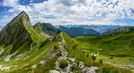
The Gantrisch area is a popular and frequently visited hiking region in the Bern – Thun – Freiburg triangle of cities. In addition to classics such as the panoramic hike Wasserscheidi – Stockhorn or the Gantrisch circuit, there are here less known and less traveled routes. One of these is described by this suggestion. At the starting point of the hike at the Gurnigel, Wasserscheide bus stop, follow the signposts for Leiterepass. After the parking lot on the so-called Panzerplatte, it is worth looking westwards towards the Schwyberg. To the east, Lake Thun with the adjacent peaks and the moraine landscape with Lake Dittlig appear. An alpine road leads uphill to the Gantrischbeizli Obernünenen and the alp of the same name. Here the Gürbe river originates. Shortly after, turn left towards Schwalmere. Through pastures and forest you reach a path to the Alp Gustiberg. A trail leads at times steeply through pastureland up to the Schwalmere mountain pass. This is the highest point of the hike. On the south side of the Nüneneflue, past some short exposed sections, you reach the Leiterepass. From here the view extends north over the Central Plateau up to the Jura. To the south, the Simmental and Diemtigtal can be spotted. To the east, the Stockhorn is visible. The descent follows to the Alp Obernünenen. On a familiar path, you reach the end of the hike at the Wasserscheide bus stop.

Pavements
- Street (13%)Trail (58%)Path (29%)
Best to visit
- suitableDepends on weather
Directions
- Wasserscheidi – Obernünenen - Schwalmere – Leiterepass – Obernünenen - Wasserscheidi
Equipment
- We recommend the following equipment: sturdy hiking boots, medium-sized backpack with hip belt, sun protection, rainwear, hiking poles, first aid kit, picnic, sufficient fluids, mobile phone.
Directions & Parking facilities
- Public transportation
Outbound: By train to Thurnen (or Schwarzenburg) and then by bus to Gurnigel, Wasserscheidi
Return: By bus from Gurnigel, Wasserscheidi to Thurnen (or Schwarzenburg) and then by train
Additional information
- Association Berner Wanderwege, Bern, Tel.: 031 340 01 01, E-Mail: info@beww.ch, Homepage: www.bernerwanderwege.ch
Literature
- Hiking book Short hikes 2 of the Berner Wanderwege, order at: https://www.wanderplaner.ch/sommer/web-shop/
License (master data)
Safety guidelines
- This route runs entirely or partially on signposted trails of the mountain hiking trail category
Map
- Swisstopo hiking map 253T Gantrisch 1:50,000, order at: https://www.wanderplaner.ch/sommer/web-shop/