Mountain summer on Mägisalp


- 1:45 h
- 5.76 km
- 62 m
- 530 m
- 1,829 m
- 2,232 m
- 403 m
- Start: Hasliberg/Planplatten
- Destination: Hasliberg/Käserstatt
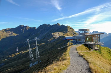
Just the magnificent view from Planplatten alone would be worth a trip to this area. Whether from the viewpoint or from the Alpen tower, the new panoramic restaurant, the scenery is equally impressive: Almost vertically below lie the huts of Schlafenbielen on the Arnialp, down at the bottom the deeply incised Gental. The panoramic view is overwhelming. Peak after peak!
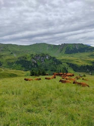
The well-maintained path first leads with an even gradient 200 m down to the high path, which runs beneath the mighty rock bastions Rothorn and Glogghüs. The view to the Engelhörner, the Wetterhorn group, the Eiger and the Brienzer ridge is incomparable. At the huts in the Hääggen alpine pasture, a mountain inn now invites you to rest. With slight ups and downs, you reach the saddle on the northern side of the Leitistöcke, which forms the boundary between Mägisalp and Balisalp. Looking back into the wide alpine basin walked through, one understands that the legend of the origin of the cow procession is set precisely in this area. Ahead the destination, the mountain station of the gondola Wasserwendi/Twing - Käserstatt, is already visible. It is also a popular starting point for beautiful high-altitude hikes.

Good to know
Pavements
Best to visit
Directions
Hasliberg/Planplatten - Mägisalp/Hääggen - Hasliberg/Käserstatt
Equipment
We recommend the following equipment: sturdy mountain boots, medium-sized backpack with hip belt, sun protection, rainwear, hiking poles, first aid kit, picnic, sufficient fluids, mobile phone.
Directions & Parking facilities
Outbound: from Brünig station by bus to Hasliberg/Reuti. Then by gondola from Hasliberg/Reuti to Planplatten.
Return: from Käserstatt by gondola to Hasliberg/Twing. Then by bus to Brünig station.
Additional information
Bernese Hiking Association, Bern, Tel.: 031 340 01 01, e-mail: info@beww.ch, homepage: www.bernerwanderwege.ch
License (master data)
Safety guidelines
This route runs entirely or partly on mountain hiking trails.
Map
Swisstopo hiking map 1:50,000 255T Susten Pass
Nearby