Over the Furggeli to Adelboden


- 7:10 h
- 18.50 km
- 1,600 m
- 1,280 m
- 1,023 m
- 2,387 m
- 1,364 m
- Start: Matten
- Destination: Adelboden
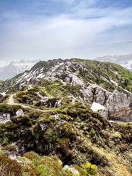
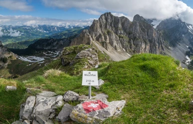
From Matten station to the village center and along the Färmelbach stream upstream. Keep the direction at the road bend and continue ascending on the old, narrow natural road. Because of the relatively steep gradient (up to 34%, which was definitely too much for the snowplows!), in 1972 a new access route into the Färmeltal was built, which also enabled access in winter. Today, hikers mainly use the old road leading through the gorge-like forest valley to Färmel/Stalde. Here, the valley widens. Groups of maples enrich the picture of the elongated scattered settlement of Färmel. Above the fir forest belt cut through by avalanche routes, the steep walls and ridges of the Spillgerte and Rothore rise, while the Rauflihore appears gentle. At Blachti and Büel, some houses show avalanche protection walls or avalanche-spalt wedges built from stones: witnesses of harsh winters. The hiking trail bypasses the valley floor at the foot of the Albrist hill, an excellent viewpoint. At the Färmelberg huts, the well-maintained path joins the rough alpine lane, which ascends through sparse forest to Alp Grod. Magnificent view into the eastern valley end with Tüürmlihore, Gsür and Albristhore. A little higher, the bumpy path crosses the wild creek bed, ascends along the creek valley, later through the scree slope of the Gsür, and finally steeply south to the Furggeli pass gap. Abruptly, over the green Entschlig valley, you face the snow-capped chain from Wetterhorn to Wildstrubel. The view back goes over the Spillgerte group to the Pre-Alpine peaks from the Gastlosen to the Stockhorn. The descent is steep on indistinct path traces over scree and meadow slopes to Furggi's pasture terrace. Of the various descent options, sure-footed hikers choose the left path on dry ground, which crosses the steep grassy slope of the Heeli, promising a panoramic hike high above the valley of the Allebach. The path on the right is safer but less maintained. The two paths reunite at the Schärmtanna restaurant. Now you descend to the Allebach and follow it on the opposite bank to the Steinige Brügg, which connects to the village center of Adelboden.

Good to know
Pavements
Best to visit
Directions
Equipment
Directions & Parking facilities
Outbound: By train via Zweisimmen to Matten near St. Stephan
Return: By bus from Adelboden to Frutigen station
Additional information
Literature
Hiking suggestion from the hiking book Simmental - Saanenland, hiking book series of the Bernese hiking trails
License (master data)
Safety guidelines
Map
Swisstopo hiking map 1:50,000 263T Wildstrubel
Nearby