Pass hike in the border area Bern - Vaud


- 4:00 h
- 10.98 km
- 620 m
- 990 m
- 1,177 m
- 1,919 m
- 742 m
- Start: Col du Pillon, Glacier 3000
- Destination: Gsteig
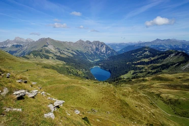
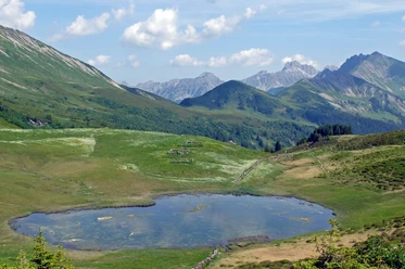
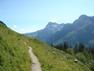
The first part of the hike crosses the terrain of the canton of Vaud. The cantonal border is not on the pass summit but unusually somewhat below on the Bernese side. At the starting point of the hike at the Col-du-Pillon bus stop, the destination Gsteig is indicated. The route should therefore be easy to find. Up to Alp Seeberg, it is also marked as “Tour des Alpes Vaudoises 46” by Wanderland Schweiz. You ascend through a forest and over alpine pastures to Lac de Retaud. From here, it is worth looking across the valley to Oldenhorn, Les Diablerets, or the Cascade du Dar waterfall. The ascent continues over a short stretch of a driving path and alpine pastures to Col de Voré. The pass summit forms the highest point of the hike. Here you cross from the canton of Vaud into Bern. Past a small unnamed mountain lake, the first longer descent over alpine pastures follows. On this section, there is a view of Arnensee. At Alp Seeberg, turn right; the destination Gsteig remains valid. Next is an ascent over alpine pastures, initially moderately steep past Alp Ober Stüdeli, then steeper through bushy meadows up to Blattipass. White-red-white painted poles mark the direction in the pathless section. Descent over pastures to Alp Topfelsberg. To Vordere Walig, you can now walk freely on a driving road with no noticeable elevation changes. Straight ahead, Höji Wispiel and the Wasseregrat or the Chrine, a pass, can be seen. Finally, alternating over pastures and descending through forest, you reach the destination at the Gsteig Post bus stop.

Good to know
Pavements
Best to visit
Directions
Equipment
Directions & Parking facilities
Outbound: By train to Zweisimmen and on to Gstaad, then bus to Col-du-Pillon, Glacier 3000
Return: By bus from Gsteig b. Gstaad, post to Gstaad and onward by train to Zweisimmen
Additional information
Literature
Hiking book Panorama hikes by Bernese hiking trails,
order at: https://www.wanderplaner.ch/sommer/web-shop/
License (master data)
Safety guidelines
Map
Swisstopo hiking map 1:50,000 263T Wildstrubel,
, order at: https://www.wanderplaner.ch/sommer/web-shop/
Nearby