Railway experience on the railway hiking trail


- 5:00 h
- 16.08 km
- 208 m
- 623 m
- 779 m
- 1,204 m
- 425 m
- Start: Kandersteg
- Destination: Frutigen
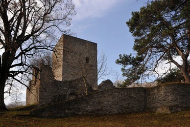
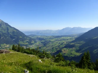
From the Kandersteg station, follow the railway embankment downstream and reach the magnificent Kander riverside path to Büel. Above the impressive road loops, the path once again runs along the railway line, which soon disappears into a tunnel. With gentle ups and downs, it continues through forest and over mountain meadows downstream to the house Uf der Flue. Magnificent views back to the Kandersteg mountain world and northwards to Felsenburg, the Mitholz railway loop, and into the Kander valley. Over another tunnel roof, one descends on a good forest path to the ruins of Felsenburg and the Blausee-Mitholz service station. On the valley side, follow the tracks at a medium elevation, mostly through forest. At railway bridges, the path sometimes makes a loop into the spanned ditch. Forest clearings allow beautiful views of the steep rock face on the Elsighorn and the valley end. The very steep descent into the valley follows an almost vertical cliff band on well-secured grated stairs. Along the railway line, it then goes to the church of Kandergrund. At Hotel Altels, cross the cantonal road and switch to the other side of the valley. On the paved little road, it goes through the valley floor to Zrydbrücke and further to Rybrügg. A short ascent leads to the ruins of Tellenburg. From the tower, enjoy a nice view of the entire Kander valley. At the same elevation, bypass the wood lying westwards, arrive via Brunni at the hamlet Tellenfeld and continue to the Frutigen station.

Good to know
Pavements
Best to visit
Directions
Kandersteg - Mitholz - Kandergrund - Rybrügg - Frutigen
Equipment
We recommend the following equipment: light trekking shoes, light backpack, sun protection, rain jacket, pocket first-aid kit, light picnic, sufficient fluids, mobile phone.
Directions & Parking facilities
Arrival: by train via Spiez to Kandersteg
Return: from Frutigen station
Additional information
Bernese Hiking Trails Association, Bern, Tel.: 031 340 01 01, E-Mail: info@beww.ch, Homepage: www.bernerwanderwege.ch
Literature
Hiking suggestion from the hiking book Thunersee - Frutigland, hiking book series of the Bernese Hiking Trails
License (master data)
Safety guidelines
This route runs entirely on hiking trails.
Map
Swisstopo hiking map 1:50,000 263T Wildstrubel
Nearby