Saanenland, where the beautiful and wealthy meet


- 2:35 h
- 10.00 km
- 259 m
- 256 m
- 1,017 m
- 1,270 m
- 253 m
- Start: Schönried
- Destination: Schönried
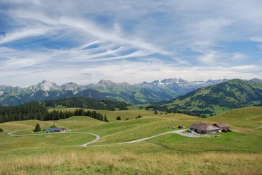
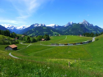
The route is located within the municipality of Saanen. The village of Gstaad, which belongs to the municipality of Saanen, is better known. At the starting point of the route, at Schönried station, you cross the Montreux - Berner Oberland Railway line towards Gstaad for the first time. Then continue on Grubenstrasse to the junction Gstaad Höhenweg – Gstaad Panoramaweg. Following the Panoramaweg, you leave Schönried and immediately reach the hiking trail to Saali, newly created in 2012. This section was made as an alternative to the heavily used and continuously potholed Grubenstrasse. The view into the Saanenland and towards the Vaud Alps clearly justifies the chosen name Panoramaweg. At the Saali signpost, continue straight towards Saanen and descend via a simple grassy path into the district Farb of the municipality of Saanen. At Farb, follow the trail along the Chouflisbach, cross the main road Saanen – Gstaad as well as the railway line, and then reach the Saane riverbank. On the right bank path, passing rest areas, the station of the world-famous village Gstaad is reached via Mättlen. From here, follow the hiking trail back to Schönried, which immediately crosses the car-free village center of Gstaad. A short detour through the fashionable village, where the beautiful and wealthy meet, is a must. The return route to Schönried leads via the Gstaad viaduct and through scattered settlements to the Gruben area. Here you choose the hiking path called Schönried Höhenweg and climb up to Schlittmoos. From there, a road leads back to Schönried.

Good to know
Pavements
Best to visit
Directions
Directions & Parking facilities
Return: By train from Schönried via Zweisimmen and Spiez or Montbovon and Bulle
License (master data)
Nearby

Download GPX file