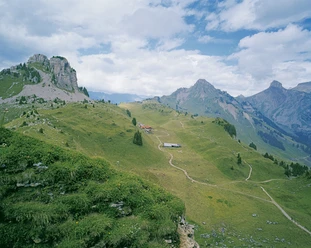
Schynige Platte circular route - top view of the three peaks


- 2:00 h
- 5.65 km
- 240 m
- 239 m
- 1,910 m
- 2,076 m
- 166 m
- Start: Schynige Platte
- Destination: Schynige Platte
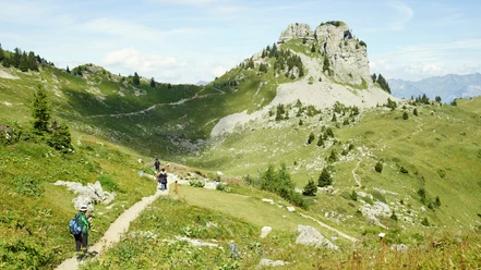
This circular hike is described in a counterclockwise direction. The diverse views make the excursion, even though short, an intense and enjoyable experience. At the starting point, follow the Lauchern sign. After crossing the railway track, a short alpine path leads, later a trail over pastures to the fork at Grätli. On this section, the view of the Eiger, Mönch, and Jungfrau trio can be best enjoyed, as the experts say. Partially, the route runs behind a ridge; the trio seems to play hide and seek. Sometimes, only the peak tips are visible. At Grätli, turn sharply left and start the return to Schynige Platte. The route is now additionally marked as a panorama trail. The path rises to the ridge, a short section passes over a metal staircase. Now, the view opens to the Brienz ridge, Lake Thun, and Lake Brienz. The Oberberghorn is bypassed on the south side. After passing an exposed spot, the path climbs up to Tuba (Daube), the highest point of the hike. Another opportunity to enjoy the panorama. Now the descent follows. First over a zigzag path, then under the rock face of Gumihorn and over grassland back to Schynige Platte. A visit to the alpine garden with around 650 plant species rounds off the experience.

Good to know
Pavements
Best to visit
Directions
Schynige Platte - Louchera - Oberberghorn - Tuba - Schynige Platte
Equipment
We recommend the following equipment: lightweight trekking shoes, light backpack, sun protection, rain jacket, small first aid kit, light picnic, sufficient fluids, mobile phone.
Directions & Parking facilities
Outbound: By train to Interlaken Ost, then to Wilderswil and onwards to Schynige Platte
Return: By train from Schynige Platte to Wilderswil, then to Interlaken Ost.
Additional information
Bern Hiking Trails Association, Bern, Tel.: 031 340 01 01, E-mail: info@beww.ch, Homepage: www.bernerwanderwege.ch
Literature
Hiking book Panorama hikes of the Bern hiking trails
License (master data)
Safety guidelines
This route runs exclusively on marked trails of the hiking path category.
Map
Swisstopo hiking map 1:50,000 254T Interlaken
Nearby

Download GPX file