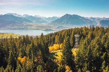
The Rothorn above Lake Thun


- 5:30 h
- 11.59 km
- 1,100 m
- 1,100 m
- 1,077 m
- 2,051 m
- 974 m
- Start: Säge
- Destination: Säge
From the Säge bus stop, we follow the signs towards Alp Obermatte, gently ascending partly on alpine roads, partly on hiking trails. At the alpine hut, turn right, continue for about 200 m on a road. Then take the left over the Zettenalp trail up to the Sigriswiler ridge. Keeping right, we cross the northeast flank of the Sigriswiler Rothorn and continue to the south side of the Rothorn. Where we meet the hiking trail coming up from Oberbärgli, turn right. After a short crossing to the north, we finally reach the small summit plateau of the Rothorn with its great view over Lake Thun towards the Bernese high Alps, with a bit of scrambling. Returning by the same path to the nameless crossroads, continue southwards down the mountain ridge to the junction P.1812 shortly after the alpine hut Oberbärgli. Keep right and shortly after the nameless rock tower reach the Bäerglichäle trail junction at P.1725. Again keeping right, continue descending, passing the Alp Bodmi, at Alp Stampf meet the ascent path and shortly after the starting point Säge.

Good to know
Pavements
Best to visit
Equipment
Directions & Parking facilities
Arrival: by bus from Thun station to Innereriz, stop Säge
Return: by bus from Innereriz, stop Säge to Thun station
Additional information
Literature
License (master data)
Safety guidelines
Map
Nearby


")
Download GPX file