To the alpine garden on Schynige Platte


- 4:30 h
- 7.80 km
- 1,350 m
- 5 m
- 649 m
- 1,970 m
- 1,321 m
- Start: Zweilütschinen
- Destination: Schynige Platte
From the station building in Zweilütschinen, first walk a few steps downhill to the railway bridge over the Schwarze Lütschine. Especially during high water, the confluence of the two mountain streams is an impressive sight: from the east, the dark-colored floods of the Schwarze Lütschine made muddy by slate sludge roll in, mixing with the water of the White Lütschine coming from the south, which originates in the limestone-rich Lauterbrunnen valley. After the bridge, turn onto the old valley road into the Grindelwald valley and pass through the entire village of Gündlischwand. A large part of the villagers today work in the depot workshop in Zweilütschinen, where the rolling stock of the BOB and the Schynige Platte railway are maintained.
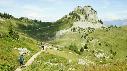
At the village exit, keep to a driveway beyond the main road and switch to the other side of the state road at the underpass. At the forest edge, just before the cable car that leads up to Iseltenläger, head uphill. Now begins the actual, sometimes extremely steep but safe ascent to Iselten. Initially, the path climbs through almost pure beech forest, which is then replaced by spruce with increasing height. The trail winds uphill in wide and tighter hairpin bends. In an area with loose rock masses, it even squeezes through a rock gate formed by two steeply rising limestone rocks. The locals call this passage "Engelstor" – one is said to hear angels sing here if they behave very well.
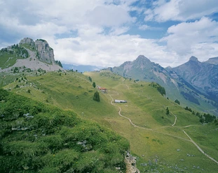
In ussren Blatti, you enter the open alpine meadow. Magnificent views down to Isenfluh and into the Grindelwald valley. Still, 200 meters of ascent must be mastered to Iseltenalp. At the huts of Usserläger, you overlook the entire fertile pasture basin of the Alp Iselten and climb through the sunny slope to Oberberg; from here, the hiking trail coming from Faulhorn leads to the station, to the alpine garden, and to the hotel on the Schynige Platte.
The view into the Jungfrau group is overwhelming. However, the Schynige Platte panorama trail promises a total panoramic view with fascinating insights (circular route 1 h 45 min, mountain hiking trail).

Good to know
Pavements
Best to visit
Directions
Equipment
Directions & Parking facilities
Getting there: By train via Interlaken Ost and Wilderswil to Zweilütschinen.
Return: By train from Schynige Platte to Wilderswil.
Additional information
Literature
Hiking suggestion from the hiking book Jungfrau Region Brienzersee - Oberhasli, hiking book series of the Bernese hiking trails
License (master data)
Safety guidelines
This route runs entirely or partially on marked paths classified as mountain hiking trails.
Map
Swisstopo hiking map 1:50,000 254T Interlaken
Nearby
