Varied high-altitude and lake hike


- 3:15 h
- 10.31 km
- 203 m
- 680 m
- 1,819 m
- 2,241 m
- 422 m
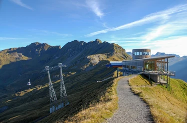
- Start: Planplatten
- Destination: Engstlenalp
From the mountain station Planplatten, where the view is still shaped by the spectacular Wetterhorn massif, it goes a short way northwards down on the ridge. At the trail junction P.2189 we follow the ridge; the path soon leads into the right-hand mountain flank. At nearly constant altitude we approach the Balmeregghorn, whose peak is climbed via a short ascent. Now straight ahead along the ridge, from where we enjoy the view to the Melchsee plain on the left side, while on the other side the view falls deep down into the Gäntel. After the nameless knoll at P.2141 m (with summit cross) we gently descend to the Tannensee, which we reach at the trail junction P.1982. In a few minutes we reach the small settlement of Tannalp, where a place to rest invites. At the chapel we branch off to the right and hike on the partly slightly exposed trail gently downhill to the hotel (with nice sun terrace) and the Engstlenalp bus stop. Be sure to also plan some time to walk in a few minutes at the end of the route to the Engstlensee. On its northern shore you can wonderfully settle down for a picnic and even enjoy a refreshing bath.
Text: Bernd Jung

Good to know
Pavements
Best to visit
Directions
Planplatten – Balmeregghorn – Tannensee - Engstlenalp
Equipment
We recommend the following equipment: sturdy mountain boots, medium-sized backpack with hip belt, sun protection, rainwear, hiking poles, first aid kit, picnic, sufficient fluid, mobile phone.
Directions & Parking facilities
Arrival: by gondola from Meiringen to Mägisalp, then by gondola to Planplatten
Return: by bus from Engstlenalp to Innertkirchen/Grimseltor (please check the timetable in advance)
Additional information
Berner Wanderwege, 031 340 01 01, info@beww.ch, bernerwanderwege.ch
License (master data)
Author´s Tip / Recommendation of the author
Be sure to also plan some time to walk in a few minutes at the end of the route to the Engstlensee. On its northern shore you can wonderfully settle down for a picnic and even enjoy a refreshing bath.
Safety guidelines
This route runs entirely or partly on marked paths of the category mountain hiking trail.
Map
swisstopo hiking map: 255T Sustenpass, 1: 50 000
Nearby
