Brienzer Rothorn, the three-canton peak


- 4:20 h
- 12.22 km
- 251 m
- 1,600 m
- 1,002 m
- 2,328 m
- 1,326 m
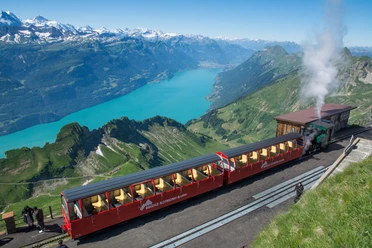
- Start: Brienzer Rothorn, Rothorn railway
- Destination: Brünig Pass
This hike is continuously marked as route 65 Napfbergland border path. Furthermore, the destination Brünig Pass is marked at the starting point and on most signposts along the way. In the first section, the path ascends comfortably to the Brienzer Rothorn. This forms a three-canton peak, as Bern, Lucerne, and Obwalden meet here. At the same time, at 2,349 meters above sea level, it is the highest point in the canton of Lucerne. The view in good visibility is sensational: among the countless peaks, only the best-known are mentioned: Säntis, Pilatus, Stanserhorn, Rigi, and Bürgenstock in the east. To the north, the view extends over the Jura to the Black Forest. From the Bernese Alps, Niederhorn, Stockhorn, Niesen, and the Eiger, Mönch, and Jungfrau are mentioned. The view of Lake Brienz is also breathtaking. Further, arms of Lake Lucerne and part of Lake Zug can be identified. After the descent to the Eisee saddle, a ridge hike follows to Arnihaggen, over Zwischenegg and Gibel to Tüfengrat. There are some exposed spots to overcome, some fitted with ropes. Surefootedness and lack of fear of heights are required. The ridge forms the canton border between Bern and Obwalden. At Tüfengrat, turn left. For a short stretch, Lake Brienz and the village of Brienz lie at the feet of the hikers. Then descend along the slope to Wilervorsass. After a short ascent, descend through pastures. White-red-white painted markers indicate the direction. Through Schäri, the destination near the Brünig-Hasliberg train station is reached.

Good to know
Pavements
Best to visit
Directions
Brienzer Rothorn - Eisee saddle - Tüfengrat - Wilervorsess – Brünig Pass
Equipment
We recommend the following equipment: sturdy and waterproof hiking boots, light to medium backpack, cold protection, sun protection, hiking poles, pocket first aid kit, snacks, tea in a thermos bottle, mobile phone.
Directions & Parking facilities
Outbound trip: By train via Interlaken Ost to Brienz, then by train to Brienzer Rothorn.
Return trip: By train from Brünig-Hasliberg
Additional information
Association Bernese Hiking Trails, Bern, Tel.: 031 340 01 01, E-mail: info@beww.ch, website: www.bernerwanderwege.ch
Literature
Hiking book Panoramic walks of the Bernese hiking trails
License (master data)
Safety guidelines
This route runs wholly or partly on marked trails of the mountain hiking path category.
Map
Swisstopo hiking map 1:50,000 254T Interlaken
Nearby


