Experience the sunrise at Hohgant


- 5:15 h
- 14.92 km
- 640 m
- 640 m
- 1,558 m
- 2,164 m
- 606 m
- Start: Habkern, Lombachalp
- Destination: Habkern, Lombachalp
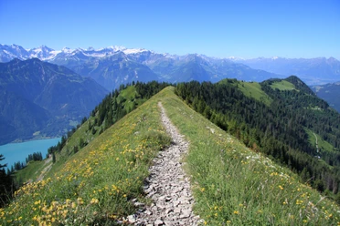
Pitch dark and deathly quiet it is at Lombachalp on this early autumn morning. Equipped with a flashlight, we set off through the high moor at Lombachalp towards Hohgant. After our eyes adjust to the darkness, the lamp soon becomes unnecessary. Thanks to the comfortable paved road, we make quick progress and have an unobstructed view of the silent and deserted moorland. At the horizon, dawn is already visible; the first colors appear in the darkness. At Möser, we turn left and quickly gain altitude on the alpine road towards Ällgäuli. At the same time, the first mountain peaks emerge from the darkness. After a short break at dawn, the actual ascent to the summit begins at the Ällgäuli alpine pasture. The first sun rays strike over the Brienzergrat and herald a great hiking day. They bathe the southern walls of the Hohgant in warm light. Thanks to the morning freshness, the ascent over numerous stone steps is much more pleasant than in the midday sun. First over meadows and then in rocky terrain, the mountain hiking trail climbs up into the rocky basin between the two peaks Hohgant and Furggegütsch. We leave the Furggegütsch on the right and choose the path to the left at the fork near the two peaks to the Hohgant.
Right on time for the mid-morning snack at 9 a.m., we have reached the summit. We are amazed on the one hand by the enormous panoramic view that makes our gaze wander insatiably. On the other hand, we are astonished by the huge area of the Hohgant summit or rather its high plateau, which is crisscrossed by millions of stones.
For the descent, we choose the southern ridge which leads directly down to Stand. The path is partly rocky and sections are strewn with larger boulders lying in wild disorder. The mountain hiking trail is well marked, but you really have to make your way between the blocks. The great panorama and the wild nature compensate for the occasional scrambling. From Stand we follow the watershed of Emme and Lombach. Extensive blueberry fields accompany us along Widegg, Bolberg, and Winterröscht. Shortly before noon, we are back at Lombachalp and look forward to a refreshment in the nearby alpine inn.
Please observe the following rules of conduct

Good to know
Pavements
Best to visit
Directions
Lombachalp - Möser - Allgäuli - Hohgant - Stand - Widegg - Lombachalp
Equipment
We recommend the following equipment: sturdy mountain boots, medium-sized backpack with hip belt, sun protection, rainwear, first-aid kit, picnic, sufficient fluids, mobile phone, change for parking.
Directions & Parking facilities
Additional information
Berner Wanderwege, Moserstrasse 27, 3000 Bern 22, info@beww.ch, 031 340 01 01
License (master data)
Safety guidelines
The hike runs on a paved road in the first part up to Möser which is not signposted as a hiking trail. The rest of the hike mostly takes place on trails classified as mountain hiking paths. The hike should only be undertaken in good weather conditions.
Map
Nearby
Download GPX file