Hiking in the area of the Lauberhorn ski race


- 2:35 h
- 9.00 km
- 1,080 m
- 1,276 m
- 2,328 m
- 1,052 m
- Start: Eigergletscher
- Destination: Wengen
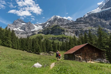
From the starting point of the hike, the Eigergletscher stop, follow the signposted destination, Wengen. The view stretches from the Schilthorn over the peaks along Lake Thun and Lake Brienz to the Grosse Scheidegg. On a path marked as a mountain hiking trail, later an alpine path, you descend to Kleine Scheidegg. Here you can enjoy the view for the last time of Grindelwald, the Faulhorn, Schwarzhorn, or the Grosse Scheidegg. Travelers heading to Jungfraujoch must change from the Wengernalpbahn to the Jungfraubahn at Kleine Scheidegg. Accordingly, the place is busy here. The railway line, opened in 1912, has become the engine of tourism, as the Jungfrau Region label shows. The route is now marked as a hiking trail and as Via Alpina 1 by Wanderland Switzerland. Diverging to the left, you continue descending past alpine pastures to the Wengernalp and then to a viewpoint with benches. From here, the village of Wengen and in the background the Gemmenalphorn and the Seefeld karst area can be seen. A panel explains the World Cup Lauberhorn ski downhill race. The view of the section with the well-known parts Hundschopf, Kernen-S, or Wasserstation is impressive. The hike continues on a service road above or then through the Baan forest. Leaving the forest at Allmend, the view of Wengen opens again. We recommend occasionally stopping and looking at the Jungfrau. Eiger and Mönch are not visible; they hide behind the Lauberhorn. Soon, the hike's destination, Wengen station, is reached.

Good to know
Pavements
Best to visit
Directions
Eigergletscher - Kleine Scheidegg - Wengernalp - Allmend – Wengen
Equipment
We recommend the following equipment: sturdy and waterproof mountain boots, light to medium backpack, cold protection, sun protection, hiking poles, first aid kit, snacks, tea in a thermos bottle, mobile phone.
Directions & Parking facilities
Outbound trip: By train to Interlaken Ost, then by Berner Oberland Bahn, Wengernalpbahn and Jungfraubahn via Kleine Scheidegg to Eigergletscher station
Return trip: By train from Wengen to Lauterbrunnen and further to Interlaken Ost
Additional information
Bernese Hiking Trails Association, Bern, Tel.: 031 340 01 01, E-mail: info@beww.ch, Homepage: www.bernerwanderwege.ch
Literature
Hiking book Panoramic hikes by the Bernese hiking trails
License (master data)
Safety guidelines
This route runs entirely or partially on marked trails of the category mountain hiking trail
Map
Swisstopo hiking map 1:50,000 254T Interlaken
Nearby


