On high trails at Hasliberg


- 1:20 h
- 4.75 km
- 420 m
- 1,045 m
- 1,435 m
- 390 m
- Start: Bidmi
- Destination: Hasliberg/Hohfluh
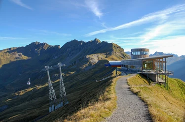
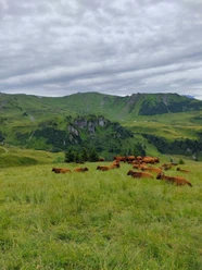
Right next to the Bidmi gondola station is a small lake. It is not suitable for swimming, but the picnic area in the nearby small forest invites a first stop for those little and big explorers who have already walked the Muggestutz theme trail (see variants). Two paths lead from here to Wasserwendi. The asphalt road on the left is mainly used in winter. In summer, the right fork is preferable. It first also runs a few steps on hard surface, but then branches left and leads along a well-developed, wide gravel path through charming mountain forest and over flower-rich alpine meadows. Along the way, the view drifts to Rosenlaui on the opposite side of the Hasli valley – the area is considered one of the most beautiful natural landscapes in the entire Alpine region. The Reichenbach meanders gently through the green valley floor, rugged jagged Engelhörner rise above it, and in the background the icy peaks of Rosenhorn and Wetterhorn shimmer picturesquely. Passing sparsely scattered farms and some holiday cottages, the path goes gently downhill. In the Fuhri area, follow the signposts towards Wasserwendi and reach the track of the Hasliberg-Käserstatt gondola on a narrow, almost level path. After passing under it, turn downhill. Steeply downhill over pastureland you reach the first houses of Hasliberg/Wasserwendi, then on a small road to the restaurant of the same name. Here you have a wonderful view of Lake Brienz with the ridge of Rothorn and Augstmatthorn above it. On a broad, scenic gravel path, it now goes via Wysstanne to Hasliberg/Hohfluh. Along the way is the artificially created bathing lake Hasliberg from a few years ago, which harmoniously fits into the mountain landscape. Thanks to its shallow depth, the water quickly warms to pleasant temperatures in early summer. A small sandy beach, lawns and beach chairs also offer a pleasant bathing experience for hikers.

Good to know
Pavements
Best to visit
Directions
Bidmi - Wasserwendi - bathing lake - Hasliberg/Hohfluh
Equipment
We recommend the following equipment: light trekking shoes, light backpack, sun protection, rain jacket, first-aid kit, light picnic, sufficient fluids, mobile phone.
Directions & Parking facilities
Outbound: by gondola from Hasliberg/Reuti to Bidmi
Return: by bus from Hasliberg/Hohfluh
Additional information
Berner Wanderwege, T 031 340 01 01, info@beww.ch, bernerwanderwege.ch
Literature
License (master data)
Safety guidelines
This route runs entirely on hiking trails.
Map
Nearby