On the Sonnenweg to the viewpoint


- 4:30 h
- 13.18 km
- 540 m
- 1,300 m
- 1,059 m
- 2,245 m
- 1,186 m
- Start: Hasliberg/Käserstatt
- Destination: Hasliberg/Reuti
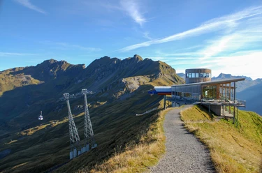
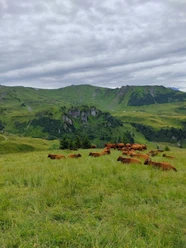
The cable car from Wasserwendi Twing conveniently takes us to the starting point Käserstatt at 1827 m. Impressive is the view to the Wetterhorn, Wellhorn and the jagged Engelhörner, popular with climbers. From here you follow the path called Sonnenweg by Hasliberg Tourism always towards Planplatten. You are accompanied, especially during the alpine spring, by a rich alpine flora, many butterflies and bumblebees. With some attention and luck you may also encounter marmots. The cattle on the alpine pastures seem to enjoy the lush grass. On the right side you always have the dominant Wetterhorn in view. From the Alp Hääggen with self-service snack bar the path becomes steeper, really steep is only the short final ascent to Planplatten. At the highest point is the cable car station with the original Alpentower with a restaurant. Once at the top, the view opens to the Susten area and the Hasli valley, a magnificent panoramic view. Immediately after the Alpentower there are two viewing points with panorama boards that inform us about the exciting mountain world. At the second viewpoint there is a take-off point for paragliders. The beautiful spot invites prolonged stays. A part of the long descent runs on the new ViaBerna, Route 38. The upper part of the path leads through very beautiful alpine landscape, is steep and somewhat rocky. From Gummen it mostly runs on a good forest road. In the lower part you walk a section of the exciting Muggestutz children's adventure path with many places to rest.

Good to know
Pavements
Best to visit
Directions
Käserstatt – Planplatten - Hasliberg/Reuti
Equipment
We recommend the following equipment: sturdy mountain shoes, medium-sized backpack with hip belt, sun protection, rainwear, hiking poles, first aid kit, picnic, sufficient fluids, mobile phone.
Directions & Parking facilities
Arrival: from Brünig Hasliberg by post bus to Hasliberg Wasserwendi Twing, with LSB to Käserstatt
Return: from Hasliberg Reuti with LSB to Meiringen or by post bus to Brünig-Hasliberg
Additional information
Bern Hiking Trails Association, Bern, Tel.: 031 340 01 01, E-Mail: info@beww.ch, Homepage: www.bernerwanderwege.ch
License (master data)
Author´s Tip / Recommendation of the author
Those who do not like steep descents can take the cable car from Planplatten to Mägisalp and reach Hasliberg Reuti on foot in about 1h 15m with 645 meters of descent.
Safety guidelines
This route runs entirely or partly on marked paths of the mountain hiking trail category.
Map
Swisstopo hiking map 255T Sustenpass 1:50,000
Nearby