Gnarled Swiss stone pines and icy peaks

- 3:35 h
- 11.48 km
- 200 m
- 1,180 m
- 1,329 m
- 2,340 m
- 1,011 m
- Start: Männlichen, mountain station
- Destination: Brandegg, station
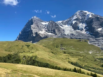
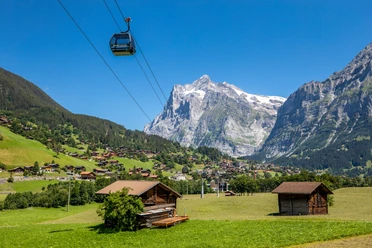
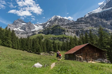
From the Männlichen mountain station, a detour to the Männlichen summit is worthwhile. This junction between the valleys of Grindelwald and Lauterbrunnen offers a magnificent view over the whole region and far beyond. Back at the gondola station, about 300 meters of the path run along the well-known high trail towards Kleine Scheidegg before our path turns down towards Bustiglen. Along the way, flower-rich mountain meadows enchant, and in the distance famous peaks like the Wetterhorn, Schreck- and Lauteraarhorn, and of course the trio Eiger, Mönch, and Jungfrau. In the area of the “Schwarzi Flue,” alpine roses line the hiking trail and on a hill, a row of magnificent, gnarled Swiss stone pines stands. The hiking trail continues through pine and spruce forest to Alp Bustiglen, where cows moo and pigs grunt contentedly, curiously peeking through the fence. Below Bustiglen is a small valley called “Arvengarten.” Here is probably one of the most beautiful and largest Swiss stone pine populations in the Bernese Oberland, as the Swiss stone pine thrives here, as in the whole Northern Alps, rather rarely. However, our path already turns off from Alp Bustiglen towards “Unterer Brand” (Unterbrand on the map). Soon the path enters the Itramenwald, a beautiful Swiss stone pine-spruce forest interspersed with moors and ponds. Clearings also repeatedly offer views of the mighty north face of the Eiger. From Unterer Brand, you head towards Itramen/Aspen and later encounter signposts leading to the Brandegg stop and the restaurant of the same name. On the sun-warmed terrace, you can literally relax splendidly, perhaps enjoying the legendary apple fritters, the house specialty.

Good to know
Pavements
Best to visit
Directions
Directions & Parking facilities
Arrival: by train to Grindelwald Terminal and by gondola to Männlichen
Return: by Wengernalpbahn from Brandegg to Grindelwald, then by train towards Interlaken
License (master data)
Map
Nearby