Ridge tour from Engstligen to the Kander valley


- 4:50 h
- 11.68 km
- 1,000 m
- 1,040 m
- 1,871 m
- 2,658 m
- 787 m
- Start: Engstligenalp
- Destination: Sunnbüel
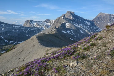
Shortly after the Engstligenalp mountain station, we follow the signs towards Kandersteg and after a few minutes enter the first ridge section, the Ärtelegrat. This leads directly to the striking rock tower of the Tschingellochtighore. We follow the ridge for almost 600 meters in altitude. Then it continues on the southeast side of the Tschingellochtighore up to the scenic Engstligengrat. A final gentle ascent takes us to P.2659, the highest point of this ridge tour. Along the wide back of the Engstligengrat, we walk for about 500 meters towards a nameless crossing where we leave the Engstligengrat. The path then turns left into the Tälli, initially steep and then leveling off into grassy terrain. After the crossing in the Tälli, where we keep left, one should be careful not to lose sight of the white-red-white trail markings, which lead slightly to the right. We then cross gently ascending below the large rock face to the next ridge section, the Schwarzgrätli. On this short ridge section, at P.2381, we come to a crossing where signposts indicate the Sunnbüel railway station (with identical time indication). This can be reached by two options: the first leads downhill to the Schwarenbach mountain hotel and then on a road across the Spittelmatte plateau to Sunnbüel. The second option leads towards the Üschinengrat via a scenic high-altitude hike to Sunnbüel.

Good to know
Pavements
Best to visit
Equipment
Directions & Parking facilities
Arrival: by bus from Frutigen station via Adelboden to the valley station below the Birg
Return: by bus from Sunnbüel valley station to Kandersteg station
Additional information
Literature
Hiking book Bernese Oberland of the Bernese Hiking Trails
License (master data)
Safety guidelines
Map
Swisstopo hiking map 263T Wildstrubel 1:50,000
Nearby