To the mountain of mountains


- 5:20 h
- 12.04 km
- 1,700 m
- 50 m
- 779 m
- 2,343 m
- 1,564 m
- Start: Frutigen
- Destination: Niesen
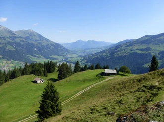
From Frutigen train station via the Engstlige, then ascend along the Leimbach. In the village, head downhill on the old main road and immediately keep to the lush meadows of Niderfeld. On a narrow footpath with a flat course to the houses of Winklen. Now begins a five-hour mountain hike that demands a lot of stamina, as it is not only about overcoming 1550 meters of elevation, but also adapting to different terrain conditions. Along the Gunggbach, it first goes gently up into the forest and crossing it downhill into the deeply incised Heitibach gorge. This is crossed far above. After also mastering the steep slope to the house at Hangi, there is finally a short break. At the beautiful viewpoint Eggweid, you already enjoy a remarkable panoramic view. Passing the pasture ridge, the path gently descends into the Schlumpach gorge and then gains the pasture ridge in Senggi in two short steep stages. Past the hut Ogis Senggi on the Unterniesen alp, up to the Oberniesen alp and into the ridge saddle between Niesen and Fromberghore, the Cheesbödi. Magnificent the view into the Simmental and backwards to the Bernese high Alps! Still ahead lies the steep slope traverse to Schafboden before you reach the scenic height of Niesen with the mountain house and railway station over the southern subpeak.

Good to know
Pavements
Best to visit
Directions
Frutigen - Eggweid - Senggi - Oberniesen - Niesen
Equipment
We recommend the following equipment: sturdy mountain boots, medium-sized backpack with hip belt, sun protection, rainwear, hiking poles, pocket first aid kit, picnic, sufficient fluids, mobile phone.
Additional information
Bernese Hiking Trails Association, Bern, Tel.: 031 340 01 01, E-mail: info@beww.ch, homepage: www.bernerwanderwege.ch
Literature
Hiking proposal from the hiking book Lake Thun - Frutigland, hiking book series of the Bernese hiking trails
License (master data)
Safety guidelines
This route runs entirely or partially on mountain hiking trails.
Map
Swisstopo hiking map 1:50,000 253T Gantrisch
Nearby


")
")
")