Where the ice avalanches thunder down from the Jungfrau

- 3:20 h
- 9.34 km
- 800 m
- 150 m
- 1,199 m
- 1,884 m
- 685 m
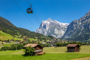
- Start: Wengen
- Destination: Wengernalp
A few steps south of Wengen station, you walk through the underpass under the railway tracks and without significant altitude difference on the small road upstream towards Schiltwald. Noticeable on both sides of the mountain slopes are the massive avalanche defenses that are meant to support the protective forest below in its function. On the left, the mighty wall of the Männlichen chain rises, while on the other side of the valley the fingers of the Lobhörner set a striking accent. But a special treat is the view of the firn-glossed Jungfrau.
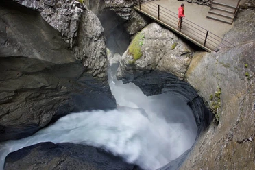
In Schiltwald, in the destination area of the Lauberhorn downhill course, a short detour to the Staubbach benches should not be missed: The view of the Staubbach waterfall and the other mountain streams shooting over the high rock wall in the Lauterbrunnen valley is unique. The narrow pasture path continues upstream. In the forest, the path climbs more steeply and finally winds in some switchbacks up to the viewpoint above the Staldeflue: What a deep view (caution with children)! 800 m below, vertically under the observer, lie the houses and roads in the valley floor. The activity down there seems like toys. The view backward extends over Wengen, Lauterbrunnen, and Isenfluh out to the Bödeli and to the bright scree fields at the Sieben Hengsten beyond Lake Thun.
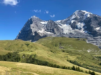
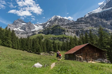
Gently ascending, one reaches a forest clearing at Stalden with a forest road that approaches the huts on the Mettla almost horizontally (to Wengernalp 30 min). Gradually the road turns back into a path and, maintaining direction, leads to the Biglenalp. On the way, you enjoy a wonderful view of the massif of the Jungfrau rising abruptly beyond the Trümmelbachtal. No less impressive than its rock walls and rugged glaciers is the mighty rock block of the Schwarzmönch. The regular roar of the meltwater is occasionally drowned out by the thunder of a glacier break crashing down the valley. Now the path turns downstream and climbs, bypassing the lateral moraine of the once deeper-reaching Eiger glacier, up to the valley station of the ski lifts in Wixi and to the station on the Wengernalp (from In Gassen–Wengen 1h15).

Good to know
Pavements
Best to visit
Directions
Wengen - Schiltwald - Mettla - Biglenalp - Wengernalp
Equipment
We recommend the following equipment: sturdy mountain boots, medium-sized backpack with hip belt, sun protection, rainwear, hiking poles, first aid kit, picnic, sufficient fluids, mobile phone.
Additional information
Association Bernese Hiking Trails, Bern, Tel.: 031 340 01 01, Email: info@beww.ch, Homepage: www.bernerwanderwege.ch
Literature
Hiking suggestion from the Jungfrau Region Brienzersee - Oberhasli hiking book series of the Bernese hiking trails
License (master data)
Safety guidelines
This route runs wholly or partially on marked trails of the mountain hiking trail category.
Map
Swisstopo hiking map 1:50,000 254T Interlaken
Nearby