To the ibex at Augstmatthorn


- 6:30 h
- 16.23 km
- 1,113 m
- 1,129 m
- 1,040 m
- 2,135 m
- 1,095 m
- Start: Habkern
- Destination: Habkern
From the post office in Habkern, head slightly downhill to the bridge spanning the deeply incised Traubach. Follow the path in the forest towards Bolsiten, but at the fork turn right over the Bolbach. At the forest edge, take a footpath on the mountain side upwards over the sunny slopes and in a long arc to the huts of Schwendallmi. Beautiful view back over part of Habkern and the elongated Güggisgrat. After about 10 minutes, the first variations are already available (to Bodmi–Horet/Läger–Habkern 2h20; to Bodmi–Horet/Läger–Harder Kulm 2h45).
Continue gently uphill over meadows until about 1 km before Lombachalp, where you return to the path. Point 1559 on Lombachalp is marked on the topographic map with the field name Roteschwand.
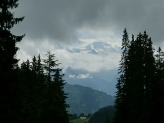
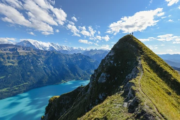
The ascent to Augstmatthorn can be seen in its full length from here. After the large left-hand bend, leave the path towards Lombach. The trail now climbs steeply to Bodmisegg (to Bodmi–Schwendallmi–Habkern 1h10, to Bodmi–Horet/Läger–Habkern 2h50, to Bodomi–Horet/Läger–Horetegg–Harder 2h30). But the actual, sweat-inducing climb still lies ahead! The path zigzags past point 1771 (to Tritt–Niederried 3h, to Tritt–Ober Horet–Harder 2h30) to the ridge height and then continues as a clearly visible ridge path to the Augstmatthorn viewpoint. The view from here is considered one of the most beautiful in the entire Lake Brienz area. The long, narrow lake basin lies deep below; beyond the lake rise Schynige Platte and Faulhorn chain, behind them the snow giants of the main chain of the Bernese Alps in their finest splendor. Particularly interesting is also the view to the north into the Emme catchment area, to Hohgant, and to the west into the Habkern valley.
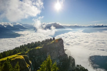
The path then leads southwest along the ridge to Suggiture and very steeply down to Tritt (to Niederried 2h30). Magnificent is the view down onto the Bödel, the alluvial plain between Lake Brienz and Lake Thun. The high trail over Horetegg (to Ringgenberg 2h15) and Ober Horet (to Harderkulm 1h15) offers magnificent close and distant views on both sides of the ridge. It then descends very steeply to the hut in Horet Läger, and the following 400 m descent to the valley floor takes less than 1 km of path. Over magnificent alpine meadows, it goes back from Tschieme via Schwendi and Bolsiten to Habkern.
Please observe the following code of conduct

Good to know
Pavements
Best to visit
Directions
Habkern - Lombachalp - Augstmatthorn - Horetegg - Habkern
Equipment
We recommend the following equipment: sturdy mountain boots, medium-sized backpack with hip belt, sun protection, rainwear, trekking poles, first aid kit, picnic, sufficient liquids.
Directions & Parking facilities
Additional information
Bernese Hiking Trails Association, Bern, Tel.: 031 340 01 01, Email: info@beww.ch, Homepage: www.bernerwanderwege.ch
Literature
License (master data)
Safety guidelines
This route runs entirely or partly on marked trails of the mountain hiking path category
Map
Nearby


Download GPX file